The Internet has become a gateway to education, work, healthcare, finance, safety, and participation in modern life. Yet connectivity is still uneven. According to the ITU’s 2025 Facts and Figures, around 6 billion people are now online, but 2.2 billion remain offline. The remaining gap is not only about coverage on a map; it is about terrain, affordability, disasters, energy supply, rural isolation, and the economics of building infrastructure where conventional terrestrial networks are hard to deploy [1].
This is where non-terrestrial networks, or NTNs, enter the story. Instead of relying only on towers, cables, and ground infrastructure, NTNs extend connectivity upward: to satellites, high-altitude platforms, tethered drones, UAV relays, and aerial intelligent surfaces. The central idea is simple but powerful: when the ground is too sparse, too damaged, too expensive, or too congested, the network can rise into the sky.
My research on NTNs has focused especially on the low-altitude part of this ecosystem: UAVs, drones, aerial data collection, tethered platforms, aerial RIS, and intelligent wireless control. Together, these works explore how flying platforms can collect data, restore service, extend coverage, improve fairness, reduce energy consumption, and make future 6G networks more adaptive.
From fixed infrastructure to flying infrastructure
Traditional cellular networks are designed around fixed base stations. That works well in dense urban areas, but it becomes less efficient when users are scattered across farms, mountains, deserts, disaster zones, or temporary hotspots. A UAV can change the geometry of the network: it can fly closer to users, establish strong line-of-sight links, and reposition itself as demand changes.
One of our early questions was: if a UAV is collecting data from a field of low-power IoT sensors, where should it fly, where should it hover, and for how long?
In our work on aerial data aggregation and field estimation, we studied a UAV that flies over a finite spatial field to collect samples from distributed IoT devices. Instead of forcing every small sensor to forward data through multi-hop terrestrial links, the UAV becomes a mobile collector. The key challenge is a hovering-versus-traveling dilemma. Hovering longer improves data collection in one area, but traveling too much wastes time and energy. We showed that there is an optimal way to divide the field into subregions, choose hovering points, decide hovering durations, and plan the trajectory so that the UAV gathers the needed information efficiently [2], [3].
This idea is especially relevant for environmental monitoring, precision agriculture, industrial inspection, and remote sensing. In these settings, the network is not always a fixed grid. Sometimes the network is a flying robot that visits the data.
Making UAV networks sustainable
A UAV can bring connectivity to difficult places, but it carries its own limitation: energy. A drone that runs out of battery is not a network anymore. This makes energy-aware trajectory design a central problem for aerial communications.
In our work on energy-efficient trajectory optimization for UAV-assisted IoT networks, we considered a UAV powered by both solar energy and charging stations. The goal was not simply to maximize data rate, but to jointly balance data transmission, total energy consumption, and fairness among IoT terminals. The UAV learns how to adapt its flight path to changing network conditions while avoiding energy outage [4].
This is an important shift in thinking. Aerial networks should not only be fast; they should be sustainable. In remote deployments, humanitarian missions, and rural IoT, the real bottleneck may not be spectrum alone, but energy availability over time.
Laser-powered UAVs: keeping aerial networks in the sky
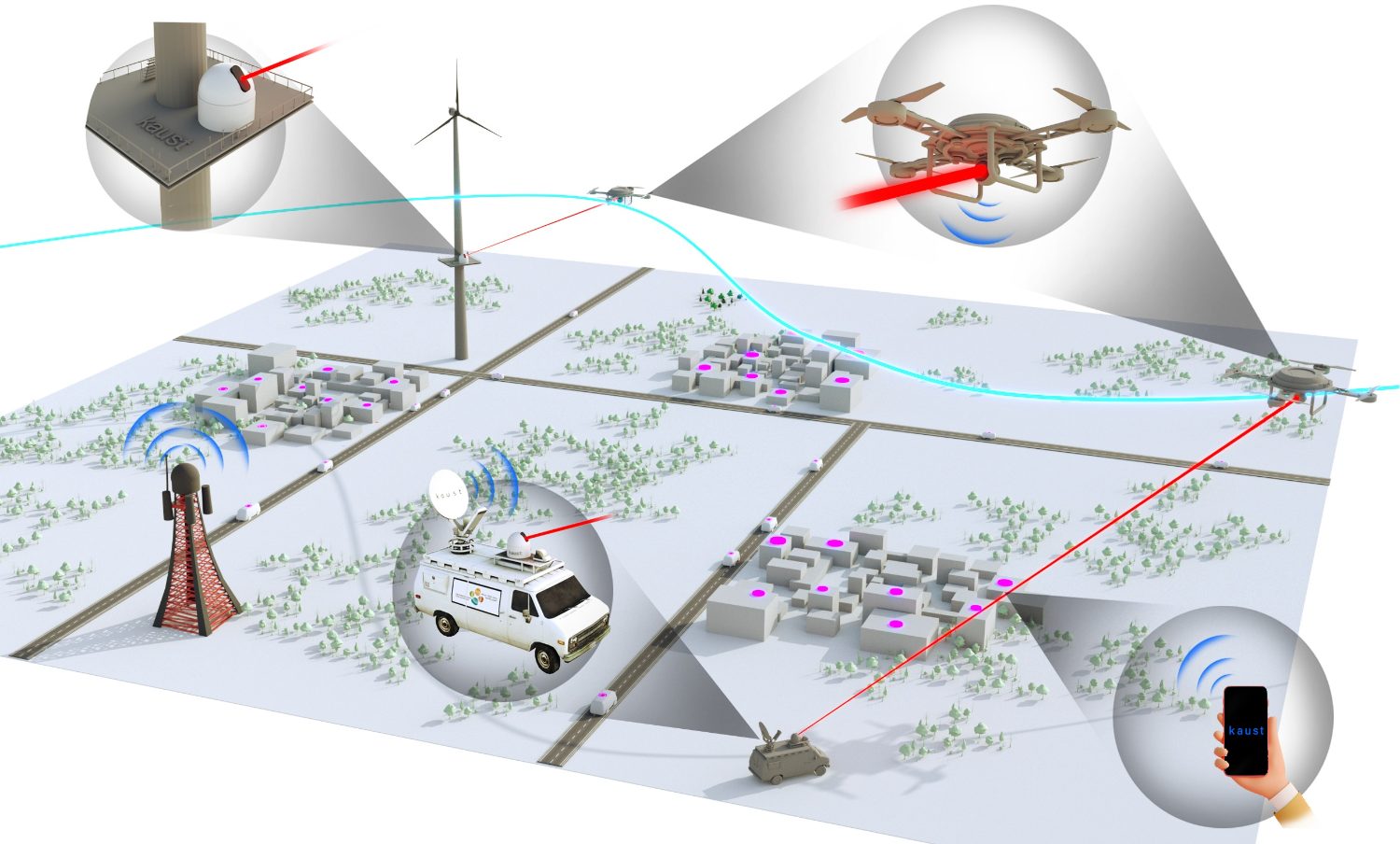
We later pushed this idea further with laser-empowered UAVs for passive IoT networks. In that architecture, the UAV is powered by a ground laser source, while battery-free IoT devices communicate through bistatic backscatter with help from a power beacon. In simpler terms, the system studies how to collect data from devices that do not carry conventional batteries, using external energy sources to keep both the UAV and the sensing infrastructure operational. The proposed optimization increased harvested data by about 90% under different operating conditions [5], [6].
This line of work points toward a future where aerial networks can serve not only connected users, but also passive, low-cost, and battery-free sensing systems.
Tethered drones: when endurance matters more than mobility
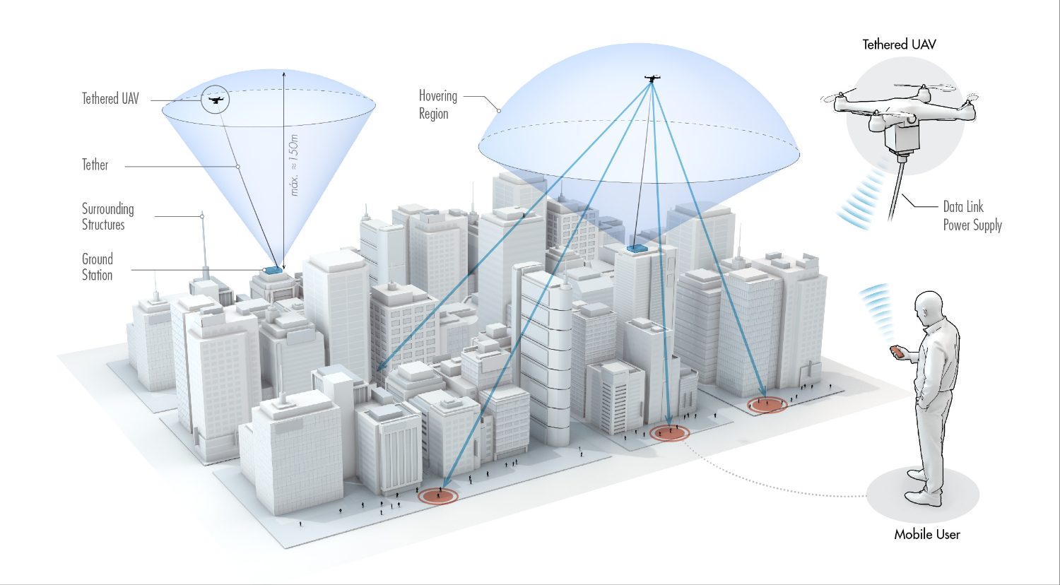
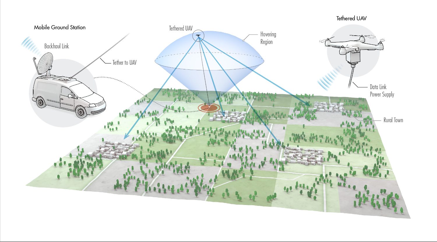
Untethered UAVs are flexible, but their endurance is limited. Tethered drones offer a different compromise. They are less mobile, but the tether can provide both power and data backhaul from a ground station. That makes them attractive for long-duration coverage in crowded events, emergency zones, remote construction sites, and traffic hotspots.
In our work on optimal deployment of tethered drones, we compared tethered and untethered UAVs for cellular traffic offloading. The question was: where should a tethered UAV be placed so that it maximizes coverage for a cluster of users while respecting the physical constraints of the tether? Using stochastic geometry, we derived the user association regions, coverage probability, and optimal deployment structure. The results showed that tethered UAVs can outperform regular UAVs when suitable ground-station locations and tether lengths are available [7].
This is a practical result with a practical message. In many real deployments, the best aerial network node may not be the one that can fly anywhere, but the one that can stay in the air long enough to matter.
Fairness and access in aerial NOMA networks
Coverage alone is not enough. A UAV relay may serve many users at once, and those users may experience different channel conditions, interference levels, and hardware limitations. Future NTNs must therefore decide not only where the UAV should be, but also how resources should be shared.
In our UAV-assisted cooperative and cognitive NOMA research, we studied a UAV relay serving secondary users in a hotspot area. NOMA allows multiple users to share the same time and frequency resources, but practical imperfections matter: hardware impairments, imperfect channel estimates, and residual interference after successive interference cancellation can all degrade performance. We developed deployment, clustering, channel assignment, and resource-allocation methods that achieve max-min fairness while using much less power and computational time than benchmark approaches [8], [9].
The broader lesson is that aerial connectivity should not simply maximize the best user’s speed. It should serve the network fairly, especially in hotspot or emergency scenarios where many users compete for limited resources.
Aerial RIS: turning drones into programmable wireless mirrors
UAVs do not have to act only as flying base stations or relays. They can also carry reconfigurable intelligent surfaces, or RISs. An aerial RIS is like a programmable mirror in the sky: it can reflect and reshape wireless signals to improve desired links, suppress harmful interference, or protect communications from eavesdroppers.
In our aerial RIS research, we studied how a RIS-equipped UAV can enhance physical-layer security. The system virtually partitions the RIS so that one portion strengthens the legitimate user’s signal while another portion increases the effect of artificial noise on an eavesdropper. We then optimize both the three-dimensional deployment of the aerial RIS and the RIS partitioning strategy. The result is a dynamic security mechanism that can significantly improve secrecy performance and converge quickly enough to be useful for adaptive deployment [10], [11].
A related line of work studies aerial RIS-aided uplink NOMA under residual hardware impairments. This brings several strands together: UAV deployment, RIS partitioning, NOMA, IoT, and practical nonideal hardware. Instead of assuming perfect devices and perfect interference cancellation, the model accounts for the imperfections that low-cost IoT networks actually face [12].
This is where NTN research becomes especially exciting. The sky is not only a place to put more base stations. It can become a programmable layer of the wireless environment.
Networks that respond when the ground breaks
NTNs are also critical when terrestrial infrastructure is damaged. Earthquakes, floods, wildfires, and other disasters can destroy base stations, block roads, and disrupt backhaul exactly when communication is most urgent.
In our post-earthquake network restoration work, we modeled how seismic events can cause building collapse, road closure, and base-station failure. We then developed a routing algorithm for movable and deployable resource units, or MDRUs, that uses this statistical damage model to restore communications more efficiently. The approach reduced travel time by up to 31% compared with a blind distance-based method and improved coverage restoration in many simulated disaster scenarios [13].
This research connects NTN thinking with resilience. A deployable communication unit, drone, or aerial platform is most valuable when the existing network is unavailable. In that sense, NTNs are not just about expanding capacity; they are about keeping society connected under stress.
Toward spaceborne and sensing-aware 6G networks
My broader NTN vision extends beyond UAVs. Future 6G networks will likely integrate terrestrial systems with low-, medium-, and geostationary-orbit satellites, high-altitude platforms, and low-altitude aerial platforms. These layers can complement one another: satellites can provide wide-area coverage, HAPs can support regional connectivity, UAVs can serve local hotspots, and terrestrial networks can deliver dense urban capacity [14].
One promising direction is the use of free-space optical and millimeter-wave crosslinks for inter-satellite and aerial networking. Free-space optics can support extremely high data rates, but narrow laser beams require precise pointing, acquisition, and tracking. Millimeter-wave control links may help establish, align, and maintain these optical paths when pointing uncertainty becomes severe.
Another direction is space internetworking: routing data through moving three-dimensional constellations of satellites, aerial platforms, and ground stations. Unlike terrestrial fiber, the topology of an NTN is constantly changing. Routes and handovers may need to be predicted in advance based on orbital motion, atmospheric conditions, platform mobility, and service demand.
Finally, the rise of eVTOLs, cargo drones, and aerial mobility points to a future where communication and sensing must be designed together. Base stations may need to connect aerial vehicles while also sensing their positions, velocities, and trajectories. This makes integrated sensing and communication a natural fit for low-altitude NTNs: the same infrastructure that provides data links may also support air-traffic awareness, blockage prediction, and safe navigation.
The long-term goal is not simply to add drones or satellites to today’s networks. It is to build a truly three-dimensional communication fabric: one that can move, sense, adapt, and recover. From UAV data collection to laser-powered aerial IoT, from tethered drones to aerial RIS, and from disaster recovery to spaceborne routing, NTNs point toward a future where connectivity is no longer confined to the ground.